Top Hiking Trails
Hiking has become a very popular and favorite outdoor activity for every Malaysian. It can be planned at anytime with just a pair of hiking shoes and a walking stick.
Nowadays, there are many neighbourhood hiking trails discovered by the locals.
From a pathless hill covered by the raw and thick bushes, and now they've been paved out with a proper and clean trail for the hikers to ascend to the summit and feel the achievement of being at the top and so close to the fluffy clouds.
Every trail will have a different scenic route and surrounded by beautiful flora and fauna.
Start your hiking marathon today. Let the uphill and downhill remind us the concept of climbing through our lifelong journey.
Below are the top choices of Hiking Trails :-
1. Taman Tugu
Highlight : There are in total 32 CP (Stations) if you complete entire CPs, it will take min one and half or 2 hours.
If you wish to go for a shorter route, you can exit at certain CPs and it will lead you back closer to the ending point. For example, CP 14 will have an exit linking to CP 20. So you can skip CP 15 - CP 19.
Pls take note that the longest route is CP 15 - CP 20. Once you enter into this route, there is no turning back .
Level : Easy to Moderate
Park hours 7am-6.30pm.
Entry Free,
Address : Taman Tugu Off Persiaran Sultan Salahuddin, 50480, Kuala Lumpur.
2. Ketumbar Hill
Alamat: Ketumbar Hill, Jalan Ketumbar, Taman Cheras, 56100 Kuala Lumpur.
Distance : 400meters
Duration of Hike : 2 hours with return
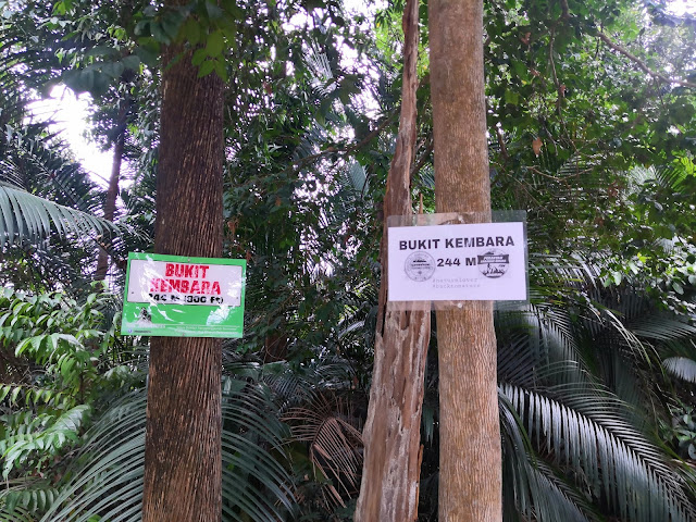
3. Bukit Kembara
Distance : 250 meters
Duration of hike : 1 hour
Entrance : Beside the Chinese Altar
4. Broga Hill
Address : Broga Hill Semenyih
Entrance :
Parking at the plantation may cost you RM2.00. [Update: 9/4/17: the attendant is now collecting parking fees charged at RM1 per passenger].
5. Bukit Gasing
Landmark : Children Playground.
Parking : Outside the main gate
Address : Waze or Google Maps: Jalan Tanjong 5/4, Section 5, Bkt Gasing, Petaling Jaya.
Duration of Hike : 1 - 2 hours
Level : Easy
6. Apek Hill
Duration of Hike : 2 - 3 hours to the resting platform
To waterfall : 7 - 8 hours
Distance : 12km
7. Kota Damansara Community Forest Reserve
Distance and time The Harmoni to Denai Tiga Puteri trail using the Unity route is approximately 3.5 kilometres one way and should take 1 1/2 hours to complete.
Scout - Temuan - Sahabat - Unity - Denai Tiga Putreri
Level : Moderate - Difficult
8. Setia Alam Community Trails (Lake Mirror)
Time and distance : 12 km route / 3 hours
Level : Easy - Moderate
9. Bukit Taisho
Bukit Taisho is a 1.7 mile moderately trafficked out and back trail located near Bahau, Negeri Sembilan, Malaysia that features beautiful wild flowers and is rated as moderate.
10. Bukit Besi Trailhead
Trail Detail
1. Parking at OCBC Alam Damai.
2. Walk over the opposite entrance, Small steep Road with a barricade (beside Altitude 236 Condominium)
3. Hike up about 5 minute, you will see the water tank.. Turn right and enter to the trail.
11. Puchong wawasan Hill
Highlight :-
Trail 1 - Shorter and easier (Approximate 40 - 1 hours)
Trail 2 - Longer and more steep (1 hour - 1.30 hours)
12. Sri Bintang Trails
Highlight : This hills is separated by 2 peaks. Peak 1 & Peak 2
Peak 1 : Sunrise watching spot. It's featured with a power station tower , and some small resting hut built by local community. The view is facing residential areas and town.
Peak 2 : This is facing west. So it's good for sub set watching. The view is facing NKVE highway. This platform has been set up with some basic amenities such as chatting corners, a swing, a wishing tree, a man-made labyrinth and small farm.
No matter standing on which Peak, you will have a panoramic view of both peaks. You can holistically see the entire rolling hills from Peak 1 to Peak 2. It's a 360 degrees viewing. It's so much astonishing.
Level : Easy. The route is not long. But it's rather steep at the beginning. It's ascending all the way up to the peak 1. To proceed to Peak 2, you will then incline to a down slope and re-ascend to Peak 2. The pathway in between the peak 1 & 2 is featured with a proper stairs.
13. Desa Petaling Trail ( 青龙山)
Highlight : The entire trail is set alongside a cliff. There is a spot for photo shooting. This spot is after you get into a rock cliff, you will walk along the cliff. On one side, you can see a beautiful city landscape. The trail is not difficult. But there are a lot of ascending and descending point.
Alternative: there are 2 ways of completing the trail. One is via the cliff and another is via inner path. For inner path, there is a flat pathway, you can see beautiful lawn and bushes. Suggest you enter via cliff and exit via inner path
Duration : 1 - 1.30 hour
Level: Easy to Moderate
Waze to Desa Petaling Trail ( Park along Amadesa Condominium)
14. Bukit Serdang Hiking Trails
Highlight : Serdang Hiking Trail is a neighbourhood hill and it's well maintained by the local community. This hill is not known by many. Perhaps it's set up remotely in a residential community. I love this hiking trail very much especially it's having a multiple spots to avoid over congestion at one time.
Features : if you enter from (Fish Pond area) Dai Hok Leng
1. Route 1 : Sunrise watching spot
2. Route 2 : Fishing pond with duckling (there is also wooden bridge for crossing the river) the wooden bridge is made by wood log. So stunningly interesting.
3. Route 3 : Towards the metal bridge (There is a small fruit and vegetable farm)
Level : Easy
Note to take : There are a lot of wild dogs. Of you're scared of dog, pls look for company.
15. Bukit Dinding
Highlight: One way up and one way down. The entire road is properly tarred. You walk alongside a beautiful thick forest as if the road going up to the Fraser hills. Full of the scent of flora & fauna.
Duration: 2 hours
Distance: 7.5km including return.
Note to take : Pls apply mosquito repellent. This hill is known as Mosquito kingdom.
16. Wangsa Cheras Hill @ Apek Hill
Highlight: Apek Hill and Saga Hill are probably the biggest mountain in Klang Valley. If you're lost in the heart of the forest, it may lead you to a completely different exit. It's better to have a company or pick a specific route before you enter to the trails.
Notes : if you're a beginner, you may opt for wangsa cheras entrance, and hike until first or 3rd station, then return to the exit. This trail will allow you with some beautiful scenery too including a resting area , power station watching area and etc.
17. Pudu Ulu Hill's Peak
Highlight: if you like the observatory from a highest point, this hill will allow you to have a breathtaking view from the top with a shortest climbing time. It won't consume a lot of your energy, you can easily reach the top and enjoy your watching spot.
The view up here is unbelievably beautiful.
Notes to take : Pls visit during evening. The sunset is indeed impressive.
There are some wild dogs too. They may bark on you while entering the forest. Pls do not tease or threaten them
Duration: 30 mins to reach the top
Level : Easy
18. Taman Rakyat Klang
Highlight : This is a public park consisting jogging track and Hiking Trail. I do enjoy their hiking trail. Simple enter from the starting point, and explore the wonders of the forest. The good part is there are alot of linked stairs. It allows you to shorten your trails in case you wish yo quit early.
Duration : 1 - 2 hours
Distance: 3 km
Hiking is just like our lifelong journey.
There are uphill and downhilll.
Despite being up or down, we will ultimately reach our destination with glorified achievement. Looking back at the trails that we'd walked by, we can see only achievement and the beautiful memories. No more fear or fright.
Standing on the peak of the hill, we see things clearer and wiser!
Follow my other Cuti-Cuti Malaysia blogs at :-
Road to local delights


Comments
Post a Comment